Search
Close this search box.

TODAY IS THE DAY FOR MAXIMUM IMPACTS FROM TROPICAL STORM ETA IN SOUTH FLORIDA

IMG-20201107-WA0073-1.jpg

TODAY IS THE DAY FOR MAXIMUM IMPACTS FROM TROPICAL STORM ETA IN SOUTH FLORIDA

TODAY IS THE DAY FOR MAXIMUM IMPACTS FROM TROPICAL STORM ETA IN SOUTH FLORIDA

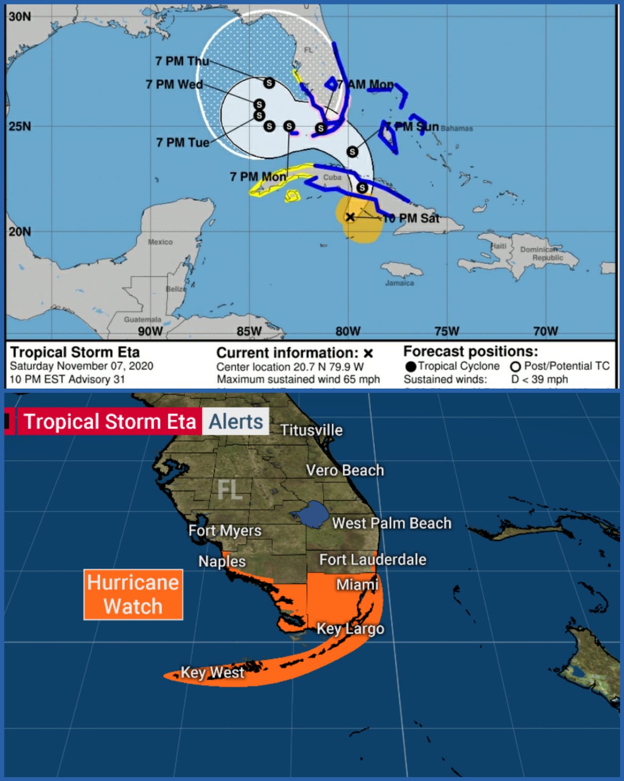
The center of Tropical Storm Eta is just moving off the north coast of Cuba and into the Straits of Florida. But the bands of heavy rain and gusty winds already extend well north of the center, and will increasingly rotate over South Florida and north to the Treasure Coast and Central Florida through the day. Maximum impacts come later today and tonight.

Eta was slightly wounded in its transit over Cuba, but it should reorganize quickly. Although in this case, reorganization does not mean a storm with a defined eye and strong winds in an eyewall near the center of circulation. The maximum winds somewhere in the circulation are forecast to increase slightly as the center moves closer to South Florida through the day. Most of the strong winds will be in bands, and may be well away from the center.

It’s not out of the question that the peak winds in some of the bands could reach 75 mph – hurricane strength – but for the most part they are expected to stay below that threshold. Because of that possibility, however, a Hurricane Watch, meaning that hurricane-force winds are possible, is in effect for Broward, Miami-Dade, and the Keys.

This is NOT a situation where we should concentrate on the forecast cone and where the center of the storm is predicted to track. The overall gustiness of the winds will be higher within about 100 miles of the center, but the energy in this storm is very spread out.

A sharp dip in the jet stream interacting with Eta has created a comma-shaped storm with the strong winds and heavy rain north and east of the center. Even as the storm arcs to the left, with the center passing over or near the Keys tonight and tomorrow, the bands of weather with strong winds will extend north as far as Central Florida and east over the Bahamas.

On the Miami-Dade and Broward County coasts, bands of heavy rain with increasingly strong wind will migrate slowly from south to north. Late this afternoon into the overnight, some wind gusts are predicted to exceed 60 mph, with a few perhaps near 75 mph.

Rain in some of the bands will be extremely heavy, so flooding is a significant threat – especially considering the ground is saturated from the previous heavy rain this year. The National Weather Service is now predicting a widespread 6 to 12 inches of rain with some spots getting up to 18 inches. Heavy rain is predicted to cover the entire southern Florida peninsula as far north as Central Florida over the next couple of days.

Because the wind will so persistently blow onshore, the ocean and bay water along the coast in South Florida, the Keys, and Southwest Florida, may rise as high as 2 to 4 feet above normal high tide. High tides will come the early afternoon and very early morning hours, so since the wind should be highest later today, the concern will be during the early overnight for flooding of low-lying areas along the coast and the inland waterways.

If your neighborhood flooded during the King Tides, be sure to park your car on high ground tonight, be aware of water levels late this evening and in the hours around and after midnight, and pay attention to any instructions from your local officials about the possibility of flooding and what action you should take.

We have the possibility of isolated tornadoes in some of these bands, but as a general rule, you protect yourself from these tornadoes like you do from the strong winds. Stay away from the windows when the winds are really blowing outside. The winds in the tornadoes are not much higher than in the strongest gusts.

In the Keys, monitor the exact track of the center of the storm. This has less to do with the strength of the winds than the direction the wind is coming from. If the storm tracks down the Keys, as now seems possible, the wind ahead of the center will come off of Florida Bay, which will push water in from the north. The wind behind the storm will push water off the Atlantic.

It appears right now that the Middle and Lower Keys will be most affected by a possible 2 to 4-foot water rise from Florida Bay, if it occurs.

All of the Keys are subject to bands of high wind from late today through daytime tomorrow, at least.

On the southeast coast, winds will start to decrease tomorrow, but it will be a noticeably breezy day, especially in any leftover rain bands. We should see more breaks in the rain, however, since dry air is forecast to wrap into the storm creating slots without rain.

Eta is forecast to slowly move into the Gulf tomorrow and Tuesday. Its future path is unclear, as is its future strength. The computer forecast models present a range of possibilities. There is a reasonable chance, however, that it stays in the Gulf for a while pulling bands of tropical moisture over the Florida peninsula that contain gusty downpours.

The threat will be for more rain on top of the rain we get this weekend, so we’ll have to stay aware.

Before the winds pick up today, be sure your phones, computer, tablets, etc. are fully charged, along with any back-up batteries if you have them. Bring in anything that can blow around in your yard or on balconies. And tonight, keep flashlights with fresh batteries handy.

Be very conscious of where you park your car today. Avoid trees and low-lying areas, even if you have to walk a ways to find a safe place, you’ll be happy you did if branches come down or the street floods. Parking garages are a good alternative if there is one nearby.

Use good sense through this. It’s going to be nasty. Don’t drive if you don’t have to. Flooding can develop very quickly in heavy-rain scenarios like this.

Below are the forecast details from the National Hurricane Center.

Leave a Reply

Your email address will not be published. Required fields are marked *

Related posts

Commercial P&C Insurance

Commercial Office Space Set for a Strong Comeback

The sustained increase in demand for office space across the nation since late 2022 suggests that the market has moved past its lowest point, according to insights from the real estate technology platform, VTS. Demand for office space began to rise in late 2022 and continued into early 2023. Since then, the office market has experienced a period of stability and growth, supported by favorable economic factors, indicating a market rebound. This conclusion is drawn from the VTS Office Demand Index (VODI), which tracks unique new tenant tour requests for office properties in key U.S. markets. The VODI serves as an early indicator of future office leasing activity. According to the index, demand for office space has grown consistently over the past 12 months, closing the second quarter with a 17% year-over-year increase and a 34% rise from the VODI’s lowest point in December 2022. A significant shift in office-based employment patterns further supports the belief that demand for office space has stabilized. After reaching its peak in August 2022, office-based employment declined by 3.9% in early 2024. However, this trend has since stabilized, and employment growth has remained steady. Additionally, a recent decrease in work-from-home rates has fueled the renewed demand for office space. “They say you can only recognize a market bottom after it has passed, and the office space market is no exception. Following what we now see as the bottom, the national demand has gradually increased, though it remains susceptible to economic challenges,” said Nick Romito, CEO of VTS. “However, the growth observed in VODI over the past 18 months, coupled with positive trends in the office-using workforce, suggests that the market has reset, and the worst is behind us.” It’s important to note that this national trend does not impact all local markets equally. Cities like Los Angeles and New York City have seen healthy growth in office space demand, while markets such as San Francisco and Washington, D.C., have experienced prolonged stagnation. In Los Angeles, office space demand surged in the second quarter, briefly surpassing pre-COVID levels, driven by an increase in the average size of office spaces sought by tenants. New York City followed a similar overall pattern, though with some softness in the second quarter. Conversely, San Francisco’s demand for office space remains unpredictable, largely due to its tech-focused workforce, which continues to favor remote work more than other industries. “Markets heavily dependent on the tech sector, like San Francisco and Seattle, are on a markedly different post-COVID recovery path compared to more diversified markets like Los Angeles and New York City. It may take some time before we see office demand in San Francisco and Seattle return to pre-COVID levels,” added Ryan Masiello, Chief Strategy Officer at VTS.

Read More
Cyber Liability

Global IT Outage Puts Business Interruption Insurance in the Spotlight

In July, a global IT outage had a significant impact on business interruption insurance policies, overshadowing the effects on cyber insurance coverages. “This incident wasn’t a result of a malicious attack, which is why typical cyber insurance policies may not have been activated,” explained Peter McMurtrie, a partner in West Monroe’s insurance sector, in an interview with PropertyCasualty360.com. “Where coverage was applicable, factors like deductible amounts, waiting periods, and coverage limits played a critical role in determining the extent of exposure,” McMurtrie noted. “Standard policies for small businesses were less likely to offer coverage, while more complex policies for mid-sized companies and Fortune 500 corporations may have included broader triggers for non-malicious outages caused by third-party software issues.” The outage was triggered by a software update on July 19, 2024, by cybersecurity firm CrowdStrike, which affected organizations worldwide using Microsoft Windows. This interruption had far-reaching consequences, including disrupting hospital systems, media outlets, financial institutions, delaying thousands of flights, and halting daily business operations. McMurtrie emphasized that while the initial impact of the outage was similar for both large and small businesses, the ability to recover operations and whether insurance covered the loss of business income varied. “Larger companies are more likely to have advanced disaster recovery plans that ensure service redundancy following unexpected outages,” he added. “Their insurance programs also tend to cover a wider range of incidents.” According to Microsoft, the CrowdStrike update error affected over 8.5 million Windows devices globally. The incident highlighted the interconnected nature of our global ecosystem, including cloud providers, software platforms, security services, and their clients. “It’s a stark reminder of the importance of prioritizing safe deployment and disaster recovery across the tech industry,” the company said in a blog post. McMurtrie pointed out that the outage’s widespread impact was largely due to its effect on organizations that are critical to societal infrastructure—sectors like agriculture, airlines, banking, energy, government, healthcare, manufacturing, and retail. “Insurance companies base their risk appetite on their ability to understand and price risks appropriately. This becomes increasingly challenging with emerging threats,” he said. “However, I anticipate that insurers will respond by clarifying policy language, refining risk selection criteria, and possibly developing new products specifically designed for this evolving exposure.”

Read More
Try your instant quote